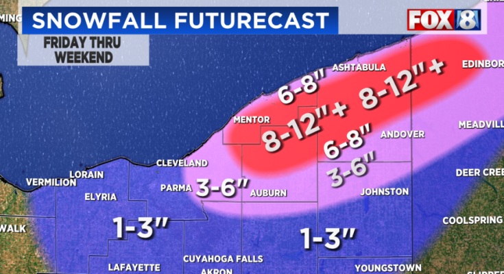
 Counties under a WINTER WEATHER ADVISORY from 7 a.m. Friday through 1 p.m. Saturday include: Lorain County, Mahoning County, Medina County, Stark County andTrumbull County.
A Winter Storm Watch that was in effect for several counties has been canceled.

Lake effect snow showers will continue across the primary snowbelt Thursday afternoon/evening. This is where another 1 to 2 inches of snow will be possible before the end of the day.

Outside of the snowbelt, it is just going to be cold and breezy. Temperatures will be in the mid to upper 20s, but it will not even feel that warm. A stiff west wind will keep wind chills in the teens.
Widespread system snow will develop late Thursday night into Friday morning. Falling snow and snowy/slick spots on the roads could slow down the Friday morning commute.

Snowfall totals Thursday night into Friday morning will generally range from 1-2″ of snow. Places south of I-76 could see 2-4″ of snow.
Lake effect snow showers will develop behind the system snow Friday afternoon. The lake effect snow showers will continue through at least Saturday. By the end of the weekend, snowfall totals across the primary snowbelt will range from 8-12″ plus. A couple inches of snow will be possible across the secondary snowbelt too.

Another strong storm system will pass south of Northeast Ohio Sunday night into Monday. This system will still get close enough to the area to bring in light system snow, especially for our southern communities. Confidence is climbing another blast of cold air will wrap around this storm system, which will trigger more lake-effect snow.

Cold will occur in three phases. The first one this week and the second, stronger one next week and a third the following weekend. THE LAST TIME WE HAD EACH DAY IN THE FIRST HALF OF JANUARY WITH BELOW-NORMAL TEMPERATURES WAS 1981!


Here’s the latest 8-Day Forecast:

Stay with Fox 8 News for the latest NE Ohio weather updates.


